- 4 km away
- 3.5 km, approx. 50 minutes
Klostersee Ebersberg
Artificially dammed bathing lake in the middle of the city. The spacious complex has lawns, a playground and sun boards. On the eastern edge of the bath there is a restaurant with sanitary facilities. Further sanitary facilities are located on the north side of the bath.
You are currently viewing a placeholder content from Google Maps. To access the actual content, click the button below. Please note that doing so will share data with third-party providers.
More Information- 5 km away
- 4 km, approx. 1 hour
Maximiliansee Steinhöring
In the north-eastern part of the municipality of Steinhöring there is an artificially created swimming pond (Maximiliansee) with groundwater supply at the sports field. The sunbathing lawns are directly at the bathing pond, the sanitary facilities are at the sports field, where you can also be entertained.
You are currently viewing a placeholder content from Google Maps. To access the actual content, click the button below. Please note that doing so will share data with third-party providers.
More Information- 5 km away
- 5 km, approx. 1 hour
Egglburger See und Weiherkett
With 33 hectares, Lake Egglburg is the largest lake in the district. It is located west of Ebersberg and borders the Ebersberger Forest in the north. The lake is 1100 meters long from northwest to southeast and up to 410 meters wide. From the Egglburger the Ebrach flows east towards Ebersberg. The lake is the beginning of the pond chain consisting of Seeweberweiher, Langweiher and Klostersee. Almost the entire lake shore is overgrown with reeds, in the south there are moist meadows, some of which are overgrown with tall perennials and only mowed once late in the year become. The entire lake is located in the Egglburger See nature reserve. The lake is an important breeding and resting place for water birds. Over 100 bird species live on the lake, including the endangered water rail and the common tern and reed warbler, which are threatened with extinction. On the damp meadows around the lake there is still plenty of large meadow button, the food plant for the caterpillars of the light blue and dark blue blue ant.
Lake Egglburg can be reached by car in a few minutes, but a hike there is also worthwhile!
You are currently viewing a placeholder content from Google Maps. To access the actual content, click the button below. Please note that doing so will share data with third-party providers.
More Information- 5 km away
- 5 km, approx. 1 hour
Aussichtsturm Ebersberg
The 35 meter high concrete tower was erected shortly before and during the First World War on the initiative of a citizens’ association on the site of a wooden tower erected in 1873 on Ludwigshöhe. Anyone who climbs the 169 steps up to the observation tower in the Ebersberger Forest will be rewarded with a fantastic view of the entire foothills of the Alps from the Berchtesgarden Alps to the Allgäu, and with particularly good visibility even the distant 3000-meter peaks can be seen. NEW: Since the solstice celebrations in 2016, the observation tower has been illuminated with 8 colored LED lights on the nights of Sundays and public holidays as well as on special occasions. For a fee of € 30, anyone can now let the tower light up for themselves from dusk until 11 p.m. The fee will be billed by the city. Interested parties please contact Mr. Karbstein on 08092-825559, email: t.karbstein@ebersberg.de. In addition to pure white light, there are also green, blue or red tones. Attention: For insurance reasons, the tower unfortunately has to remain closed in winter (first frost to last frost).
You are currently viewing a placeholder content from Google Maps. To access the actual content, click the button below. Please note that doing so will share data with third-party providers.
More Information- 50 km away
- 12 hectares in size
Fraueninsel
The Fraueninsel in the Chiemsee with its famous Benedictine convent Frauenwörth is unique and charming. | G1n | The Fraueninsel is a neighboring island to the Herreninsel in the Chiemsee, but differs very much from the Königsinsel flair of the Herreninsel. It is a very small island (approx. Twelve hectares large) with a picturesque village and Benedictine monastery. Almost 250 people live in around 50 houses on the car and bicycle-free island, including six out of 16 families on the Chiemsee who still make a living from fishing. The Fraueninsel can be reached with the Chiemsee-Schifffahrt fleet.
You are currently viewing a placeholder content from Google Maps. To access the actual content, click the button below. Please note that doing so will share data with third-party providers.
More Information- 50 km away
Wendelsteinbahn
The Wendelstein is an exposed mountain (1838 m) in the Mangfall Mountains and offers a wonderful panoramic view of the Alpine foothills as far as the main Alpine ridge. It is one of the most famous and popular mountains in the Bavarian Alps. At the mountain station itself are the Wendelsteinhaus, the Wendelsteinkircherl, the viewing platform Gacher Blick (Overview of around 200 mountain peaks) and the Wendelstein cave. The summit 100 meters higher can be reached via the summit path (serpentines and stairs, well-secured path). The summit cross, the Wendelinkapelle and the observatory are located there. There is also a weather station on the summit, the red and white transmission masts of the Bavarian radio and an observatory. This area is not open to the public and can only be viewed within a booked tour.
You are currently viewing a placeholder content from Google Maps. To access the actual content, click the button below. Please note that doing so will share data with third-party providers.
More Information- 55 km away
Schliersee
Schliersee is pure vacation. From the production of Bavarian whiskey to a rapid descent from the Schliersbergalm to the idyllic mountain lake Spitzingsee, you will experience a variety of attractions for the whole family.
You are currently viewing a placeholder content from Google Maps. To access the actual content, click the button below. Please note that doing so will share data with third-party providers.
More Information- 60 km away
Kampenwandseilbahn
Enjoy a unique view of the lake area with Chiemsee and its islands and of the Central Alps … At 1,669 m, the Kampenwand is one of the highest mountains in the region and is an attractive destination for mountain bikers, climbers and hikers. For all those who would like to comfortably and comfortably climb the Kampenwand, there is the Kampenwandseilbahn. The cable car with four-gondolas runs all year round (except for inspection times) from Aschau i.Chiemgau to the Kampenwand. The ascent takes about a quarter of an hour to the mountain station at 1461 m and is popular with hikers, climbers and air sports enthusiasts. The Sonnenalm and the Möslarn-Alm are located near the mountain station. Here, in addition to the impressive views of the Steinerne Meer of the Berchtesgaden Alps, to the Hohe Tauern with Großglockner and Großvenediger to the south or the Chiemsee to the north Excellent hiking area from easy and tranquil to challenging and sporty. The network of trails is one of the most extensive in the Upper Bavarian Alps, and the panorama trail deserves special mention: from the mountain station of the Kampenwandbahn to the Steinlingalm, you hike almost flat in about 30 minutes, always with a wonderful view of Lake Chiemsee.
You are currently viewing a placeholder content from Google Maps. To access the actual content, click the button below. Please note that doing so will share data with third-party providers.
More Information- 60 km away
Tegernsee
Over 200 years ago the first Bavarian King Max I Joseph chose the secularized monastery as his summer residence. This was the beginning of an intimate connection that not only left its mark in the Herzoglicher Bräustüberl. Culture means just as much to the Tegernsee as maintaining tradition and customs. Top events from classical to folk music or exhibitions such as those in the Olaf Gulbransson Museum and the Museum Tegernseer Tal demonstrate how lively culture is dealt with.
You are currently viewing a placeholder content from Google Maps. To access the actual content, click the button below. Please note that doing so will share data with third-party providers.
More InformationWe have put together two hiking suggestions for you, directly from the Hotel Gasthof Huber.
Short run in the morning - or in the evening....
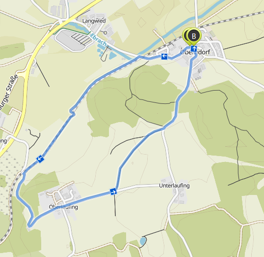
Small running loop approx. 3.6 km

Hiking Oberndorf – Traxl – Englmeng
Duration: 03:05 Length: 11.6 km
Uphill: 120 m Downhill: 120 m
Moderately difficult hike. Good basic fitness required. Mostly easily accessible paths. Surefootedness required.
You can also put together your own hiking trails on the following page:
Wanderwege Ebersberg
You can find more hiking trails on the page of the District Office Ebersberg.